| Max flying time | >60minutes | Working time | 30~60min with 0~12kgs payload |
| Max takeoff weight | 50kg | Payload | 0~12kg |
| HD Camera | Zoom 14x | Image transmission distance | 10km |
| Horizontal speed | 0~15m/s | Wind resistance | 6 |
Applications
- 3D Sand Table Modeling of Emergency Disaster
- Aerial emergency surveillance patrol
- Emergency communication network relay
- Power inspection
- Road patrol
- River conservancy inspection
Configuration
| Drone Frame | 6-rotor drone frame | 1 set |
| Flight control | Three-axis sensorThree-axis accelerometerThree-axis gyroscopeThree-axis magnetometer | 1 set |
| Remote controller | Highlight tablet with Android systemIndustrial-grade radio anti-interference abilityRemote data transmission and image transmission three in one1080P HD image transmissionSupport Ethernet/HDMI video input | 1 set |
| Li-battery | Super Lip Battery 12S 30000mAh | 2 pcs |
| Propeller | each set 6pcs | 4 pcs |
| Charger | Dual channel smart charger | 1 set |
| Cable | USB / HDMI | 1 set |
| Tools | 1 set | |
| Aluminum box | 1 set |
Suspension components

NGC-C4K: 4K HD optical zoom gimbal
Lightweight
Gimbal weight 286g
High resolution, zoom
12 million pixels, up to 4K recording
14 times zoom (3.5 times optical * 4 times digital)
High stability
Jitter Angle: ±0.01°
One-key to center
Double-click the target, center zoom function
GPS information record
Superimpose GPS information display and save to subtitle file
Available SDK
Sky data interface and ground station SDK is available
Object Tracking
| General Parameter | |
| Product | NGC-C4K: 4K HD optical zoom gimbal |
| Working voltage | 12V-25V |
| Power | 6W |
| Weight | 275g |
| Size | 96*79*120mm |
| Interface Type | Network interface |
| Control display mode | Windows system PC; Android phone, tablet |
| Environment parameter | |
| Working environment temp. | -10℃ ~ 60℃ |
| Storage environment temp. | -20℃ ~70℃ |
| Gimbal parameter | |
| Jitter Angle | ±0.01° |
| Installation method | Detachable |
| Controllable rotation range | Pitch/Tilt: +70°- -110°; Yaw/Pan: ±300° |
| Structure design scope Roll | Pitch/Tilt: +75°- -100°; Yaw/Pan: ±310°; roll: +90°- -50° |
| Maximum control speed | Pitch/Tilt: 120°/s; Yaw/Pan: 180°/s |
| Camera parameter | |
| Visible 30x optical zoom lens | |
| Sensor | CMOS: 1/2.3″; 12.71 million total pixels; maximum resolution 4152*3062 |
| Lens | 3.5x optical zoom lens F 3.85~13.4mmMinimum shooting distance: 1mm~3mm (near focus ~ far focus)Field of view (horizontal): 82~25° |
| Image storage format | JPEG |
| Video storage format | MP4 |
| Working method | Video, photo |
| Fog penetration | Electronic fog penetration |
| Exposure mode | Automatic exposure and manual exposure |
| Resolution | 25fps(3840*2160)25fps(1920*1080)Maximum capture resolution: (4024*3036) |
| Minimum illumination | Color: 0.5Lux/F2.4 |
| 2D noise reduction | √ |
| 3D noise reduction | √ |
| Shutter speed | 1/3- 1/30000s |
| Exposure | Automatic support |
| OSD | √ |
| Pointing zoom | √ |
| Pointing zoom range | 1~3.5 times optical |
| One-click zoom to single image | √ |
| Support memory card type | Micro SD card 128G (maximum) |
Easy operation
- One key adjust
- One key center
- One key down
- Follow yaw
- Target follow
NC01 FPV Camera

| General Parameter | |
| Product | Digital camera |
| Working voltage | 5V |
| Working current | 180mA |
| Weight | 67g |
| Size | 71*51*48mm |
| Interface Type | Network interface |
| Control display mode | Windows system PC; Android phone, tablet |
| Environment parameter | |
| Working environment temp. | -10℃ ~ 50℃ |
| Gimbal parameter | |
| Gimbal | Single axis |
| Controllable rotation range | Pitch: +10°- -90° |
| Camera parameter | |
| Resolution | 720P |
| Working method | Video, photo |
| Support memory card type | Micro SD card 128G (maximum) |
APP Ground Workstation

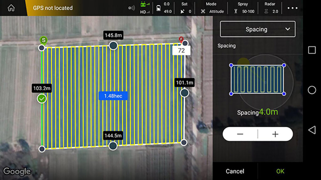
1. Android mobile phone ground workstation, Control and adjust drone’s flying parameter, provide google map, check FPV video.
2. Support hand held GPS dot device,RTK dot device,Drone GPS dot and Map for choosing, set up Automatic, semi-automatic AB working mode, flying height, spray mode, flight line spacing, flying speed, Terrain following, automatic obstacle avoidance, course adjustment, fail-sail back.
3. Query job record, flight time, spray width, dose etc.
Remote controller

1080P digital HD image transmission
NIRC10-3HDS integrated digital image transmission system, supports HDMI and network port two video source input, supports more video devices such as cameras, PTZ, pods, built-in HD FPV APP, supports video floating window function, can be displayed on any ground station APP Image, support video window scaling of any size, support the original QGroundControl video display function, open the video SDK for video integrated development.
Ultra long transmission distance
Using the new long-distance image transmission system, with the latest anti-interference radio frequency algorithm, the image remote control distance is as far as 10~20km, allowing you to explore a wider space without worrying about the flying distance during flight operations.
Industrial equipment level protection
Unmanned aerial vehicles work in harsh outdoor conditions. The NIRC10-3HDS is protected from dust and splashes on the fuselage, control switches, and peripheral interfaces to ensure stable and smooth operation of the equipment in harsh environments.
Highlight HD display
The 5.5-inch high-brightness high-definition display can clearly view real-time display information under strong light conditions.
Removable high-performance lithium battery
The high-performance lithium battery, low internal resistance, 6 hours long battery life, and stable battery curve provide stable power for the iUAV OS system, and can quickly replace the battery to ensure continuous operation


